

Annapurna Circuit Trek
Every once in a while, I dream of waking up someday to find that I’ve got wings all of a sudden and I can fly. Even if I couldn’t fly all over the world, I wish to see all the places in Nepal. In the past five years, my dream and the reality were like day and night that never overlapped. With every morning, my dream fades away along with my sleep but my enthusiasm never dies, hope remains and my wandering zeal prevails. Who needs the wings to wander? A Leopard doesn’t need wings to run like a wind and elephants walk gracefully without wings. This is the feeling that pushed me to go on the trek to Annapurna Round Circuit.
Exciting companions, burning ghumante spirit in heart, a back-pack with all the necessities, good camera and a pair of trekking shoes, what else do you need to start? Annapurna circuit is one of the top 10 trekking routes in the world. This route goes through four districts Lamjung, Myagdi, Manang and Mustang of which the latter two districts are on the other side of the mountains. Besisahar, thheadquarter of Lamjung district, is the entry point of this route which is 6 hours by bus from Kathmandu. Our journey began with the sunries and we were in Besisahar at around 2pm.
Recently, a massive earthquake had devastated Nepal and on top of that, the country was going through turmoil and chaos due to the blockade imposed in the southern border. Therefore we were also very curious to see how this had affected the travel destinations and the daily lives of the people in the mountains. We spent our first night in Besisahar. Surrounded by green hills, Besisahar has a small market but there are a lot of good Hotels, small and big for tourists. We spent our first day capturing the livelihood of Besisahar. We had planned to travel Chame of Manang from Besisahar through jeep the next day as we didn’t have enough time for hiking. It would have taken us 3 days to reach Chame by foot. But if you have enough time and if you want to feel the real pleasure of trekking as well as experience the life in the mountains up close, walking to Chame is the best option.

The next day, our jeep left for Chame at 9 am. The road was recently opened for vehicles and in a short while, we knew this was going to be a daring ride. Since it was difficult for big buses or trucks to run in that road, Jeeps were used to carry all the necessary goods to the other side of the mountain. The view of hills, waterfalls, mountain and Marshyangdi River on the way to Chame were mesmerizing. We could see many tourists hiking on the way. The road was very narrow, it was very difficult to give way for vehicles coming from opposite direction as most of the roads were single lane roads.
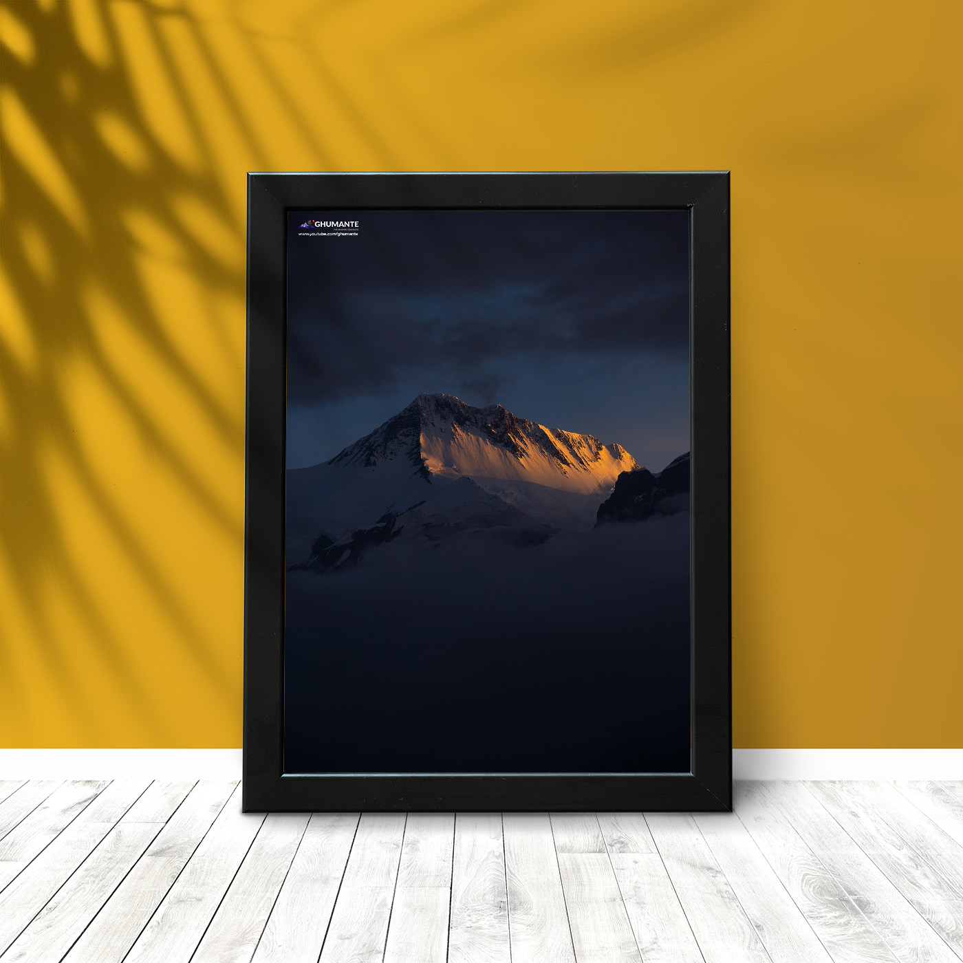
What surprised me the most was that the driver of our jeep was a 19 year old young lad whose name was Sanjay Gurung. I remembered an old advertisement in television for ‘Dhara Oil’ in which Captain Vijay Lama used to be shown saying “mutu chainchha, mutu” (Heart, you need a heart). I thought that this is exactly what someone needs to drive in this road. Not only Sanjay but most of the drivers on that road were 18-22 year old boys. We had a very friendly Manangi lady with us in the jeep who provided a lot of interesting information during our journey. It was little difficult for her to communicate in Nepali as her tongue and lips are used to speaking in Gurung language. Whenever we asked her about the time it would take us to reach Chame, she would say, “Ta for ‘taal’, Ba for ‘Bagarchaap’, ka for ‘Koto’ and then only after that, ‘Chame’”. After 10 hours of jeep ride, we reached Chame at 7pm. “Don’t ask me about the cold there”. The rays of setting sun on the Manaslu Himal in the east and Lamjung Himal on the south made them look as if they were burning. The head-quarter of another side of the mountain, Chame, was no less in providing quality services to the travlers. Everything was available there. We spent that night in Chame. Tired of traveling long and difficult road, we decided to sleep after our meal with no lingering. Besides that, we had to start our journey on foot from the next day. We charged our cameras, mobile and all other electronic devices at night.

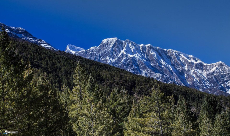
It was almost 7 am when I opened my eyes the next morning. I could hear the whistling of Marsyangdi nearby. As I opened the window, I could see the smoke coming from the chimney of the houses and Mt. Annapurna was on the background. At that time my heart screamed, “This is heaven, this is heaven.” After completing our morning chores, we began our journey on foot. Our destination for that day was Pisang village. We began to move towards Pisang, capturing the beauty of Chame on our heart and our cameras. We didn’t see any damages by the recent earthquake in Chame as we expected. We were glad that our expectations were not true. However, the huge damage in Langtang valley due to earthquake is really a very sad incident.

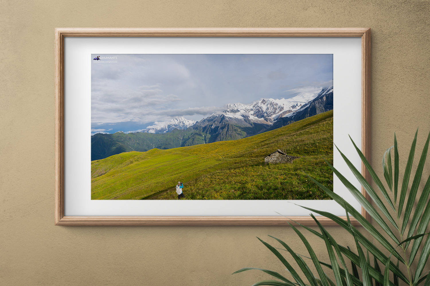
The smell of pine made our journey ever more pleasant. After one hour walk from Chame, we reached Bartang where I was awestruck to see 70 thousand apple trees, probably the largest apple farm in the country. This was the first time I tasted that many varieties of apple. I liked them very much and I guess more flavor was added by our journey to enrich taste in everything that we were having. The farm was beautiful and well managed. We noticed that the farm owner was going to establish a hotel nearby. I felt privileged to know that this was the first harvest of the year and we got the chance to taste. After taking rest for half an hour there, we moved ahead. After passing through mountains, rivers, uphills and downhills, jungles and taking few stops, we reached Pisang at 5 pm. Beautiful old houses and mountain lifestyle of Pisang was worth watching. Besides that, the view of Chauri and horses grazing on the way were eye soothing. We felt the mercury dip as we moved higher, but there was no coldness in the hospitality of the people. We got warm welcome from people there and we stayed in one of the eco-friendly hotels there. During our stay there, all the food as well as the electricity were locally produced. I was fascinated by the self-sufficiency of this Himalayan village and it changed my view towards mountain lifestyle. Since it was the first day of our walk, our bodies, most of all, our feet were aching and tired.

In the Himalayas, not only the sunrise and sunset but the night also look beautiful with dazzling stars. I don’t remember when I fell asleep staring into beautiful sky that nigh. Next day when my eyes were open, there was a cup of tea waiting for me in the dining table. I found that it’s not very expensive to travel this route and this is stands for other parts of Nepal too. However, dining can be more expensive as compared to lodging. It basically depends on how much you want to spend and how you want to spend.

Our destination that day was Manang village. While walking along the side of the shining Annapurna Himalayas and strongly flowing Marsyangdi, I felt the place was no less than heaven. After 2 hours walk from Pisang, we reached Humde. The only airport of Manang, Humde Airport, is located there. Though it’s been many years since the runway was black topped, only few planes were using the airport. We stayed there for some time. During that time we took hot tea and noodle soup, which are two most favored dishes while trekking in the mountains of Nepal. From Humde, we enjoyed the overwhelming view of Annapurna second and third as well as Pisang peak. The main source of income of this place is tourism followed by agriculture. Being photographers, it always takes us longer in a journey as we don’t want to miss any chances for an amazing shot of the landscape and lifestyle that appeal us.

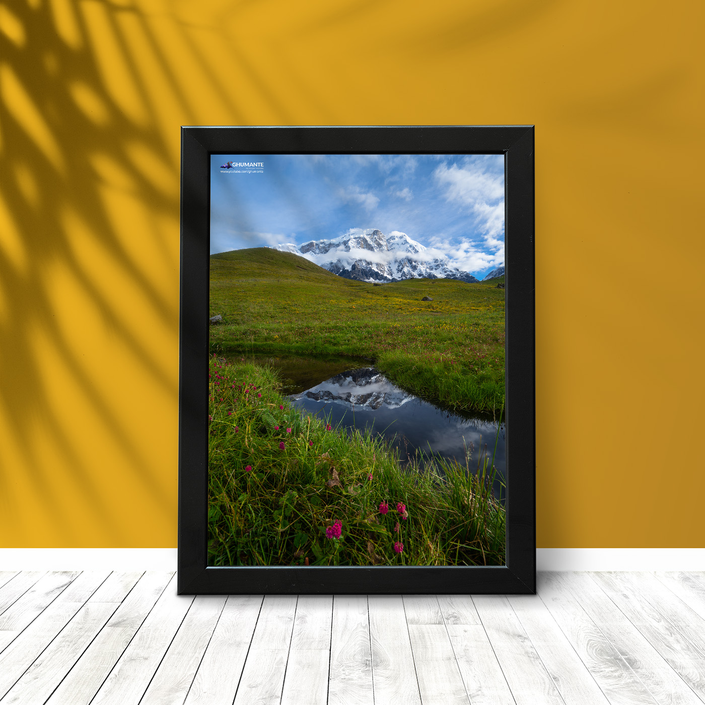
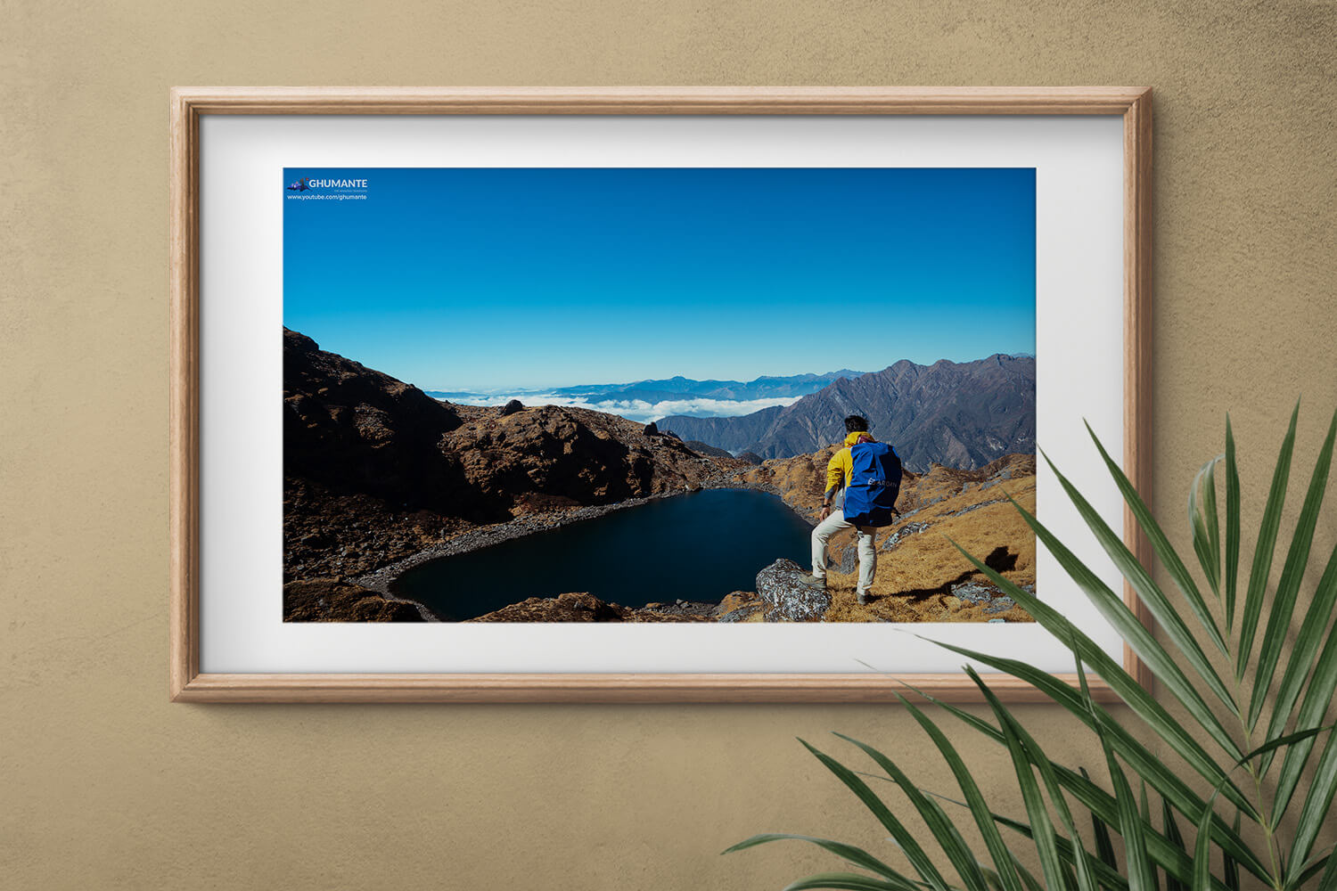
Though we planned to reach Manang village, we stayed in Braka that day. It was because we decided to go Ice Lake which would be easier to reach from Braka. Manang was only 20 minutes away from Braka. When we reached Braka, we still had some time to spare. We took our cameras and headed to Gangapurna Lake. After walking for 30 mins, a grand turquoise lake was in front of us. Mt. Gangapurna stood high, shining on itself and on it’s reflection in the lake, the view was serene. The water was not frozen but very cold. We saw many other tourists enjoying the view there.
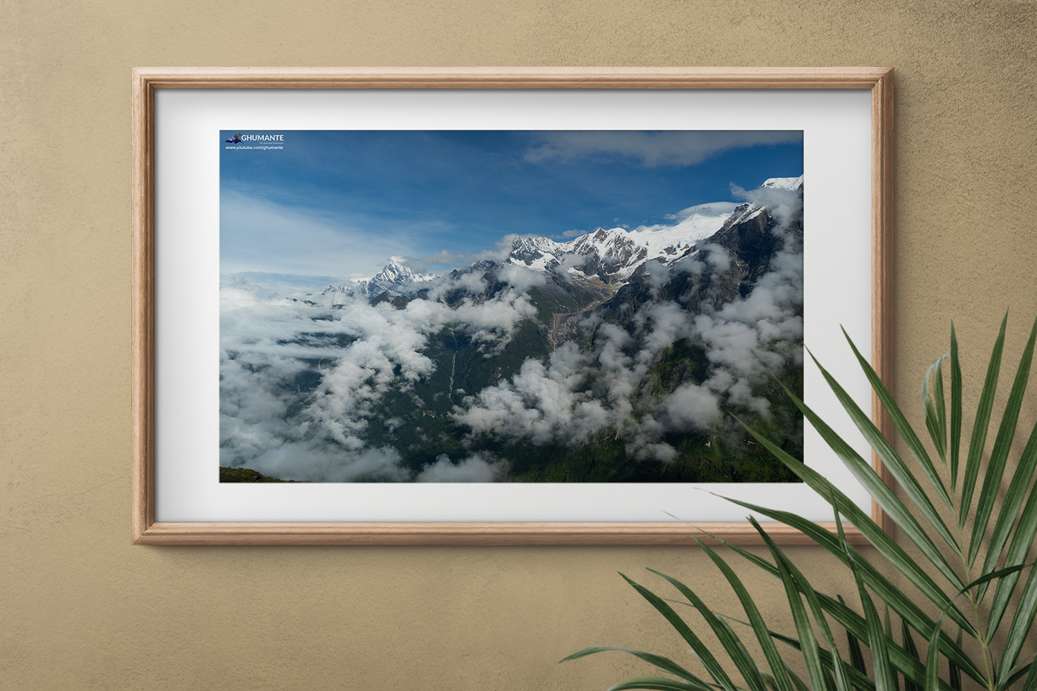
After spending sometime there, we returned back to our hotel. We had our dinner and went for sleep. For the next day, we planned to go the Ice Lake. The following morning, we took our breakfast and marched towards the Ice Lake. It’s located at an altitude of 4600m above sea level (a.s.l). The lake remains frozen for the whole year and is hence named ‘Ice Lake’. We reached there after 5 hours of uphill hike. We traveled from 3500 m a.s.l to 4600 m a.s.l on that day which was risky as a normal trekker is advised not to travel more than 1000 m a.s.l in one day. We had some local breads, chocolates and water that we carried from Braka. We could clearly see the Annapurna Range spread like a beautiful art in a white canvas. We could see Braka and Manang village down below along with the green Gangapurna Lake. We met some Czech, Italian and Australian travelers there who were thrilled like us to witness such magnificent view.

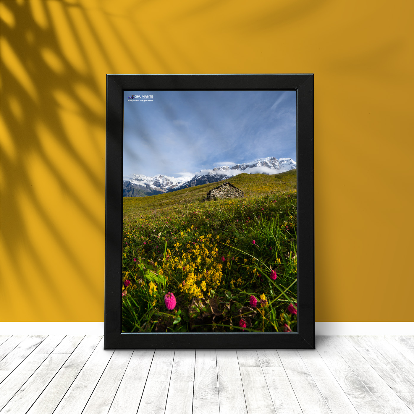
We enjoyed the natural euphoria up there for a while and then returned to Braka. It only took us 2 hour to walk down to Braka. When we reached Braka, the sun had already began to go behind the hills. Tired of the hike, we went to bed soon after taking our meals. The next morning, I woke up and saw the same glittering Himalayas. The warm hospitality of the people there was no less than before. Most people in this region are Buddhists and we were fortunate to get a chance to visit some old gumbas (monasteries). We walked past the Manang village that day. Passing through, I noticed that the village was well populated. Like the other villages on the way, we could get anything we needed in the market. I guess the recent access of the vehicles has made it easier for people to transport necessary goods.
The road bifurcated from here, one road lead to Tilicho Lake and the other lead to Thorong La Pass. Since we didn’t have enough time, we had to make a choice. So, we chose Thorong La Pass as our destination with promises to go Tilicho next time. We reached Yakkharka that day. On the way, we talked to many local people. We could see lots of herbal medicines and other local products on sale along the way. People were using mule to carry goods and some were riding horses to reach their destination. It took us 5 hour to reach Yakkharka, mostly because we spent considerable time capturing the photos as well as taking rests in between. Most of the hotels were filled with tourists and the prices were going higher as we rose higher in altitude. But it was still reasonable considering the circumstances. While we were enjoying the culture and environment of Yakkharka, lots of thoughts were playing in my mind. This trek of Manang and Annapurna area was becoming the most wonderful moment of my life. I was able to understand the reason Nepal was so popular among the tourists all over the world. It’s because of the rich culture, fascinating geography and natural beauty of the mountain region, plus the warmth of hospitality by the people.

Our next day journey was aimed at Thorong La Pass. There was the risk of altitude sickness as we climbed higher and we need to be aware of lots of things while traveling to such a high altitude. And this was going to be my first experience of above 5000m a.s.l. The road ahead got narrower and steeper . We stayed in Thorong La high camp that day and decided to cross the Pass next day. The view that we saw from there is still inscribed inside my heart. I couldn’t understand why Nepal being so rich in its natural resources, was lacking so behind in development? It took us four and half hours to reach Thorong La High camp from YakKharka. We could see white snow all around us and some dry Mountains. Luck seemed to favor us as we got to see some endangered species like Himalaya vulture and Blue sheep. At Thorong La High camp, we saw many guides providing information to their groups for the next day expedition to Thorong La Pass.

Thorong La Pass is one of the highest passes in the world. This was a big challenge for us and a little dangerous too. We were well aware of the Annapurna blizzard in the previous year. We decided to start our journey at 5am next day. That night we went to bed wearing all the clothes we had as the cold was unbearable. We woke up at 4 am next morning due to extreme cold and went directly for hot tea without washing up. Other guides and tourist were already there, sitting around the dining table. I drank around 4 cups of tea to make myself warm. Finally, we entered the most challenging phase of our expedition, the Thorong La Pass.

The road was slippery, but we moved ahead slowly without stopping. There were other guides who were providing direction and that helped us reach the Thorong La pass successfully. We reached Thorong La Pass in 2 hrs which was 5416 m a.s.l. It is situated at the border of Manang and Mustang district. We could see Himalayas of Manang on one side and Mustang on the other. I noticed that the sunrise looks more alluring from high altitude. We enjoyed warm sips of tea with the view of the sunrise there. We were soon busy taking photographs of landscape and the shots were lively. Luck was on our side as the morning was not windy that day. I felt a joy of victory over conquering the Thorong La Pass and felt the same vibes from my ghumante companions. With an almost ecstatic feeling in our hearts,we continued our journey.

Our next destination was the holy Muktinath temple. The journey was down-the-hill walk without any stop. We reached Muktinath temple of Mustang at around 12 pm. Muktinath is the god worshipped by both Buddhists and Hindus. The view on the way down to Muktinath was amazing and there were places which seemed like desert but they were full of life. After taking bath in 108 taps and worshiping lord Muktinath, we took lunch in Ranipauwa. After lunch, we were on our way to Kagbeni. Kagbeni is an ancient village of Mustang. This place is even mentioned in some of our old religious scriptures. Now the village has all the modern infrastructures and facilities. There are very good hotels with good Wi-Fi and telephone services. The vehicles reach up to upper Mustang. We stayed in Kagbeni that night. In my bed that night, I felt as if Kaligandaki River was singing lullabies for me to go to sleep.

The next day we explored more about Kagbeni. Then we took our lunch and headed to Jomsom. We reached Jomsom after 3 hrs hike. The naked hills and the amazing life of the people made Jomsom different from other places. Kagbeni and Jomsom both are located on the shores of Kaligandaki River. Jomsom, being the headquarter of the Mustang, has a big market where you can buy almost everything essential as well as airports, roads, workshops, government offices and good hotels. We spent our day exploring the culture of Jomsom and spent the night there. The next day we returned to Beni in jeep and returned to Kathmandu by bus.


This was an unforgettable journey for us. We got chance to explore different geography, culture, lifestyle, and fortunate to see the endangered species on the way. Nepal is truly blessed with natural resources as we could see a magnificent combination of the Hills, Himalayas, rivers and waterfalls. I have seen the huge tourism potential of this trekking route. It should be developed and the cultural heritages and values conserved. Extension of roads has obviously helped people of Manang but should be properly separated from the trekking route as it will directly affect the tourists who want to travel by foot. The effort of Annapurna conservation Fund is praiseworthy although there’s more capability of attract more tourists if it could extend further. We saw very few tourists during our journey, which might be due to recent earthquake. It’s the government’s responsibility to assure and inform the tourists about the secured trek route like these. Not just the government, but it is also the responsibility of all the organizations related to tourism as well as general public to protect and promote such places with such huge potential. I believe tourism can only flourish full fledged only when we have enough educated citizens and we can imagine a prosperous Nepal. I hope the number of tourists will increase more and more in coming years. I want to dedicate this piece of writing to those people of Manang and Mustang and to all the trekkers. Keep traveling, Keep exploring, Keep Clicking!
Jai Ghumante!

[author] [author_image timthumb=’on’]http://kanchanrai.com.np/tsujan.jpg[/author_image] [author_info] Tsujan is a ghumante from Damauli. He is a regular contributor and very passionate about travelling and photography .
Tsujan is a cheerful friendly guy and also good writer/poet. Nicknamed “Love Struck Romeo”, he is also a good crikcet player.
9815140787
[/author_info] [/author]
Comments


4 Comments
Angesh
Indeed Annapurna Circuit is one of the most fascinating and heart throbbing route on foot. Amazing captures with great story Tsujan. Jai Ghumante !!!
Sujan Gautam
Thank you Angesh 🙂
#jaiGhumante
deepak shrestha
can u tell me full itineary from ktm to manang then to muktinath
Sujan gautam
Hello mr.shrestha,
You can take buses from new buspark or kalanki to reach besisahar lamjung . Your first day stop will be besisahar so that you can visit local markets . From besisahar you have two options to reach chame ( headquarter of manang ) . Either you have to take jeeps or you can trek from besisahar. It will take around 3-4 days to reach chame by walking but by jeeps it will takes only 10-12 hours. And after reaching chame again you have two options to reach upper manang as from besisahar , either on jeep or trek . Difinetly trekking will help you to come over of altitude problems . After reaching upper manang there are two way s you have take a way to thorong la pass not tilicho lake . Now you have no options so you have to fully depends upon your feets. Thorong la pass is one of the highest pass of the world and 5416 meters above the sea level . You can reach thorongla high camp in 2 days of trekking from upper manang . You have to cross the pass early in the morning because day time might be more windy . After crossing the pass the next stop will be muktinath or mustang . Annapurna circuit considered as mid level trekking route . The hardest part is thorong la pass so that you have to take care of many things while crossing . Any further enquires ? You can call me on given mobile number if you any or for proper guidence you can hire me as your guide too hahaha
Thank you !